Maps N Trax Mobile App
Offline Map Viewer and Track Recorder
-
View your own maps on iPhone or iPad
-
Ideal for navigating in off network conditions or when conserving battery
-
View current location, record tracks and add waypoint annotations to your maps
-
Compatible with popular map file formats
-
Convert your paper maps
MAP N TRAX USER GUIDE | SUPPORT
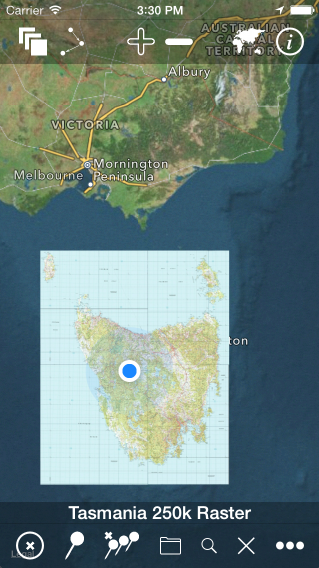
Map View with Toolbars Showing 4 Adjacent Raster Maps (Zoomed Out) and Current Location with Satellite Imagery as Background Map
Maps n Trax is an offline & online map viewer and track recorder for iOS that can import and display maps sourced from raster image and vector map file types such as PNG, JPEG, ESRI Shapefiles, ESRI File Geodatabase and Open Street Map (PBF & XML). It can utilise calibration information within some georeferenced image formats such as GeoTIFF. Therefore it is ideal for use with your own topographic or specialised maps scanned from paper or sourced from your local mapping authority. Maps n Trax can also apply navigation features to your own maps, including current location, waypoints and tracks.
Tracks can be created by automatic recording, manually or by importing as GPX or KML files. (.ozf2 & .ozfx3 files are NOT supported. See the User Guide for more information about these files.)
Many of your own imported maps of different scales can be viewed simultaneously, adjacent to or overlapping each other. Your imported maps are displayed overlaid on top of the standard iOS world map when the internet is available. A variety of background maps are available to choose from including the iOS standard maps, or it can be configured to use other online maps such as OpenStreetMaps. The background map can also be disabled altogether.
With Maps n Trax you can view your own maps on your own iPhone instead of just generic online maps or a limited selection of maps chosen by somebody else. This makes it ideal for specialist maps with details that are not available on other mapping applications, such as highly detailed topographic maps obtained from your government mapping authority or specialised maps you produce with GIS tools.
Your imported maps can also be viewed while offline with no internet access, making it ideal for a wide range of outdoor pursuits in remote locations including bushwalking, hiking, trekking, camping, cycling, touring, etc.
Maps n Trax can use map images from many common image file formats, including JPEG, PNG, TIFF or GIFF and can also read OSM-style tiled maps.
It can display large maps and can join several consecutive large maps into a single huge topographic map. The map size is limited only by the iPhone or iPad’s storage capacity.
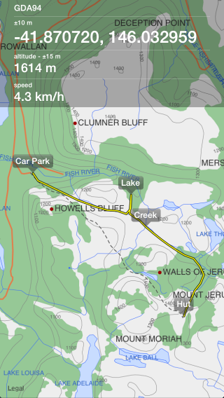
Some navigation features are also included, such as showing your current location on the map and keeping your current location centred on screen as well as recording and display of waypoints and tracks. Waypoints and tracks can be imported and exported as GPX or KML files (or exported as CSV). Multiple tracks can be displayed on the maps simultaneously and tracks with named waypoints can be searched like a directory or gazetteer.
WARNING:
Before purchasing Maps n Trax please read the User Guide carefully to understand how to prepare your map image files for Maps n Trax and to be sure that it suits your requirements. In particular pay careful attention to User Guide section Preparing Maps for Import as the process to prepare a plain image file for use as a location-calibrated and mobile-optimised map image is non-trivial. Maps can be imported without calibrating, warping or tiling and Maps n Trax will warp, tile and calibrate the image during import when possible. Maps can also be calibrated (or re-calibrated) manually within Maps n Trax after import if desired. However, preparing maps on the desktop before import is much quicker and more accurate.
IMPORTANT NOTES:
Maps n Trax works with the Spherical Mercator projection and will warp (reproject) other maps into this projection where possible during import. Unwarped maps in other projections will be less accurate for location or navigation purposes. It is recommended to warp maps into Spherical Mercator projection on the desktop before import to Maps n Trax (see user guide).
Background maps are not available when the internet is not accessible. For offline use you must supply your own maps.
Vector maps are slow to render and display compared to raster maps. Raster maps take up more storage space than vector maps.
The map accuracy, locations accuracy and navigation features should not be depended upon for situations in which inaccuracies or errors could cause danger, commercial loss or any other problems.
Do not use Maps n Trax while operating a vehicle on land, on water, in the air, underground, underwater, in space or anywhere else.
Continued use of the GPS running in the background can dramatically reduce battery life on the iPhone or iPad.
— Note: include sidebar items as well as link to app store.
Users Say…
“Our area has just gone through significant fire events in which Maps n Trax was an integral tool for tackling the fires from an aviation perspective.” – Max (fire controller)
“I have loaded 1000s of KML waypoints from Google Earth. It is an unbelievable app that is simple to use and highly recommended.” – BM987 (via App Store)
“Definitely worth purchasing for viewing your own maps.” – Mitchmiller123 (via App Store)
“Would I recommend it? Most definitely. I am more than impressed with the app.” – Pezza_Col (via App Store)